Contpark specializes in offering a robust terminal management solution. Its platform includes features for real-time visibility, workflow automation, and security, simplifying terminal operations and increasing productivity.
ContainerDepotSoftware.cloud is a specialized platform for container depot management software. The company is headquartered in Cyprus and provides a global cloud infrastructure for container yards. It offers modules for yard visualization, container allocation, and operational reporting. The solution is designed for international markets and serves clients across Europe, Asia, Africa, and the Americas.
ContainerYardMSoftware.com is a container yard management system based in Santiago, Chile. The platform focuses on security, client collaboration, and multilingual support. It delivers a scalable cloud-based solution for depots and terminals across Latin America, the Middle East, Southeast Asia, and beyond.
For advertising inquiries, please contact us at
[email protected].
: The Ultimate Positioning, Navigation and Timing System")
The Global Positioning System, commonly known as GPS, is a remarkable technology that provides precise positioning, navigation, and timing capabilities. It is a network of satellites orbiting the earth to constantly transmit signals, allowing GPS devices to accurately determine the location of a vehicle, person, or any other device capable of receiving GPS signals. Through GPS, users can plan routes, estimate speed and velocity, and calculate arrival times for their journeys.
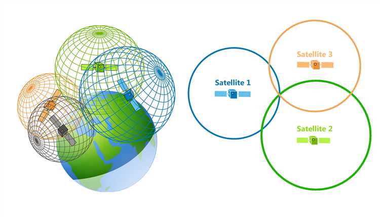
GPS works by triangulating signals from multiple satellites and using precise timekeeping to calculate the receiver’s position. By determining the distance from at least four GPS satellites, GPS devices can accurately calculate latitude, longitude, altitude, and elevation. This information is then used to provide navigation instructions, map the position on a road or a geographical map, and assist in surveying and other outdoor activities.
GPS has become an essential part of our daily lives, playing a key role in navigation, communication, and timekeeping. In addition to helping us find our way on the road, GPS enables precise positioning for various applications such as aviation, maritime navigation, and land surveying. It has also revolutionized the way we track and monitor vehicles, enabling efficient fleet management and improving traffic flow.
With its systematic infrastructure of satellites, GPS covers the entire world, making it a global positioning system. It provides precise positioning and timing information to millions of users worldwide, enabling them to navigate through the complex web of roads and routes, estimate the distance and direction to their destination, and avoid traffic. GPS has significantly increased the precision and efficiency of outdoor activities, making it an indispensable tool in a wide range of industries, from transportation and logistics to exploration and astronomy.
Global Positioning System (GPS) is a worldwide network of satellites that provides positioning, navigation, and timing services. It is a space-based system that uses radio waves to determine the precise location of a receiver on Earth.
GPS functions as a positioning, navigation, and timing system, providing accurate information about the user’s location, calculating the best routes, and synchronizing time. It is used in various industries, including aviation, marine, and automobile.
In positioning, GPS utilizes a network of satellites in Earth’s orbit and a receiver to estimate the receiver’s location on the planet’s surface. The accuracy of GPS depends on the number of satellites in view and the quality of the receiver.
For navigation, GPS provides real-time information about the user’s position, allowing them to track their movement and plan routes accordingly. It can be used for car navigation, outdoor activities, and marine pilotage.
The timing aspect of GPS involves precise synchronization of time. GPS satellites have atomic clocks that provide accurate time signals, which can be used for various applications, including scientific research, telecommunications, and financial transactions.
Overall, GPS is a versatile system that relies on a network of satellites, receivers, and radio waves to provide accurate positioning, navigation, and timing information. It has become an essential tool for various industries and everyday activities, enabling efficient travel, route planning, and destination selection.
The Global Positioning System (GPS) is a satellite-based technology that provides precise positioning, navigation, and timing information worldwide. It works by using a constellation of satellites in orbit around the Earth. These satellites transmit signals that can be received by GPS receivers, which then calculate the receiver’s location, elevation, and velocity.
To determine its position, a GPS receiver needs to receive signals from at least four satellites. These satellites transmit signals that contain information about their location and the precise time the signals were transmitted. The receiver measures the time it takes for the signal to travel from each satellite to the receiver, and uses this information along with the known location of the satellites to calculate its position.
In addition to positioning, GPS also provides navigation and timing information. By constantly monitoring the signals from multiple satellites, the GPS receiver can calculate the receiver’s velocity and direction of travel. This information can be used for navigation purposes, such as determining the best route to a destination or guiding a vehicle or vessel along a specific path.
The timing aspect of GPS is crucial for precise timekeeping. GPS satellites have highly accurate atomic clocks on board, which are synchronized with one another. By receiving signals from multiple satellites and comparing the time information in these signals, a GPS receiver can accurately determine the current time.
GPS technology has various applications in different fields. In the military, GPS is used for precise positioning, navigation, and target tracking. In the maritime industry, GPS enables accurate pilotage and navigation in open waters. In the aviation industry, GPS aids in navigation and guidance during flights. In the surveying and geodetic fields, GPS is used for precise location measurements and mapping. Additionally, GPS has become an integral part of location-based technologies, such as mobile apps and devices that provide location information and route guidance to users.
In conclusion, GPS is a satellite-based system that provides precise positioning, navigation, and timing information. It relies on a constellation of satellites in space, which transmit signals that are received by GPS receivers on the ground. By measuring the time it takes for these signals to reach the receiver, along with information about the satellite’s location, the receiver can calculate its own position, elevation, velocity, and direction. GPS technology has numerous applications in various industries and has revolutionized the way we navigate, travel, and keep time in the modern world.
The Global Positioning System (GPS) is a technology that provides accurate positioning, navigation and timing services globally. It uses a constellation of satellites to transmit signals to receivers on the ground, allowing users to determine their precise location, velocity, and time. GPS is widely used in various applications, including mapping, surveying, aviation, and mobile devices.
In positioning and navigation, GPS plays a crucial role in determining the geographical coordinates of a location. By receiving signals from multiple satellites, a GPS receiver can triangulate its position, providing accurate latitude and longitude readings. This information is essential for various purposes, such as route planning, pilotage, and geolocation-based services.
GPS also ensures synchronization and accurate timekeeping. The timing signals transmitted by the satellites allow devices to maintain precise time references, which is crucial for activities that are dependent on accurate and synchronized timing, such as communication networks, infrastructure monitoring, and scientific experiments.
The accuracy of GPS positioning depends on various factors, such as the number of satellites in view, the quality of received signals, and the capabilities of the receiver. With advancements in technology and the introduction of new satellite constellations, GPS systems have significantly improved their accuracy, enabling centimeter-level positioning in certain applications, such as surveying and geodetic measurements.
GPS has revolutionized the way we navigate and explore the world. From finding our way in unfamiliar cities to guiding vehicles on long trips, GPS provides reliable and real-time information about our location and the best routes to our destination. It has also made aviation safer by providing accurate navigation and pilotage information to pilots, ensuring precise and efficient flight operations.
With the widespread use of GPS, various industries and sectors have benefited from its capabilities. From creating detailed maps and improving emergency response systems to enabling precise agriculture practices and enhancing outdoor recreational activities, GPS has become an indispensable tool in our modern world.
GPS, or Global Positioning System, has revolutionized navigation in the outdoors. With the help of radio waves transmitted by satellites in space, GPS devices receive signals to determine the position and location of the user. Whether it’s for pilotage in the air, maritime navigation at sea, or mobile navigation on land, GPS has become an essential tool for travelers around the world.
Through a systematic process of satellite signal reception and triangulation, GPS devices can accurately determine the latitude and longitude of the user’s position. With the help of sensors like compasses and accelerometers, these devices can also provide information about the direction and speed of travel.
One of the key features of GPS in navigation is the ability to set waypoints and navigate to specific destinations. Users can input their desired destinations into the device, and it will calculate the distance and provide a route to follow. This makes travel planning easier and more efficient, as users can rely on GPS to guide them to their desired locations.
GPS in navigation also includes mapping capabilities. With maps stored in the device’s memory or accessed through an internet connection, users can view their position in relation to the surrounding area. This helps them navigate through unfamiliar terrain and find their way back to known points of interest.
GPS is powered by a complex infrastructure of satellites in orbit around the Earth. These satellites continuously transmit signals that are received by GPS devices on the ground. By receiving signals from multiple satellites, GPS devices can accurately calculate the user’s position through a process called trilateration.
Overall, GPS in navigation has transformed the way people navigate and travel in the world. It provides reliable and precise positioning information, making it easier for users to reach their destinations efficiently and safely.
The Global Positioning System (GPS) is a constellation of satellites that provides precise geolocation and timing information to users worldwide. GPS technology uses a network of satellites orbiting the Earth to calculate the position, velocity, and altitude of an object or person with great accuracy.
GPS is widely used in various fields, including navigation, surveying, and communication. It allows for precise route planning, tracking, and positioning in both outdoor and indoor environments. With GPS, users can determine their exact geographic coordinates, enabling them to navigate unfamiliar areas, find their way, and pinpoint locations on maps.
Furthermore, GPS plays a crucial role in timing synchronization. By utilizing satellite signals, GPS receivers can accurately determine the time, allowing for precise timing in various applications. This technology is particularly important in sectors that require precise time synchronization, such as telecommunications, financial transactions, and scientific experiments.
In addition to its navigational and timing capabilities, GPS also benefits the maritime industry. It enables ships and boats to navigate accurately, ensuring safe and efficient travel. GPS can also assist in maritime surveying and mapping, providing precise data on waterways, shorelines, and underwater features.
GPS technology works by triangulation, using signals from multiple satellites to determine the position of a receiver. The receiver calculates its position based on the time it takes for the satellite signals to reach it. This enables high precision in determining the position and allows for accurate tracking and monitoring in real-time.
The use of GPS is not limited to land-based applications. Airborne vehicles, such as airplanes and helicopters, utilize GPS for navigation, positioning, and tracking. GPS ensures safe and accurate flight by providing pilots with real-time information on their precise location, altitude, and direction.
The Global Positioning System (GPS) is an advanced technology that provides precise positioning, navigation, and timing information. It has revolutionized the way we travel and navigate the world.
The GPS system works by using a network of satellites in space to transmit signals to GPS receivers on Earth. These receivers can then calculate their exact position based on the time it takes for the signals to reach them from multiple satellites. This process is known as trilateration.
The history of GPS dates back to the mid-20th century when scientists and engineers began exploring the idea of using satellite signals for positioning and navigation. The development of GPS was initially driven by military applications, with the United States Department of Defense taking the lead.
GPS technology has since evolved, and it is now used in various sectors, including aviation, maritime, surveying, transportation, and outdoor activities. GPS systems are installed in cars, boats, airplanes, and mobile devices, providing real-time navigation and accurate positional information.
In the field of navigation, GPS has significantly improved the accuracy and ease of finding directions and routes. It enables users to input their desired destination and receive turn-by-turn guidance to reach it. GPS also offers features such as waypoint marking, which allows users to save specific coordinates along a route for future reference.
In aviation and maritime applications, GPS plays a crucial role in pilotage and marine navigation. It helps pilots and sailors estimate their position, track their speed and elevation, and navigate through complex routes. GPS has largely replaced traditional methods such as celestial navigation, compass readings, and dead reckoning.
GPS relies on precise synchronization and timing to function accurately. Each GPS satellite has an onboard atomic clock, which provides an extremely precise time signal that is used to calculate position. The GPS system also relies on a network of ground-based control stations to monitor and adjust the satellite clocks and to ensure the overall accuracy of the system.
The development of GPS has also benefited from advancements in space technology and astronomy. The initial constellation of satellites was launched into space to provide global coverage and ensure that at least four satellites are visible from any point on Earth at any given time. This allows for accurate positional calculations and better reception of the satellite signal.
The GPS infrastructure and technology continue to evolve, with ongoing efforts to improve the accuracy, availability, and reliability of the system. GPS is not only a tool for navigation and positioning but also a valuable source of data for scientific research, weather forecasting, and disaster management.
In conclusion, GPS has revolutionized the way we navigate and estimate position by providing an accurate and reliable positioning, navigation, and timing system. Its impact is felt across various sectors, from everyday car travel to complex aviation and maritime operations. GPS technology has enabled us to explore the world with confidence and has become an essential part of our daily lives.
The advent of satellite-based systems has revolutionized the field of positional information, navigation, and timing. GPS, or Global Positioning System, has become the ultimate tool for accurately determining one’s location on the Earth’s surface. It relies on a network of satellites orbiting the planet, which transmit signals that can be received by GPS receivers or sensors on the ground.
With this satellite-based navigation system, individuals can easily navigate and plan their routes, whether on foot or in vehicles. Road maps have given way to digital maps that can be accessed on mobile devices, providing real-time guidance and ensuring precise positioning. The days of getting lost during a journey are now behind us thanks to GPS technology.
Not only does GPS play a vital role in everyday travel, but it has also become an integral part of various industries. In aviation, pilots rely on GPS for accurate pilotage and ensuring the safety of their aircraft. In the military, GPS technology enables precise targeting, enhancing the effectiveness of operations. Additionally, GPS aids in geodetic surveys, mapping, and astronomy, providing accurate and reliable data for scientific research and exploration.
The systematic and precise timing provided by GPS has also revolutionized timekeeping. The GPS system relies on highly accurate atomic clocks on board the satellites to ensure precise time synchronization. This technology is utilized in various fields, such as communication systems, where timing is crucial for seamless data transmission, and financial transactions, where time stamps are essential for record-keeping.
As the technology continues to advance, GPS is becoming more robust and reliable. The introduction of additional satellite constellations, such as GLONASS and Galileo, has further improved the accuracy, availability, and coverage of the GPS system. New advancements in miniaturized GPS modules and telemetry systems have also made high-precision positioning accessible to a wide range of industries.
In conclusion, the advancements in GPS technology have transformed the way we navigate and plan our journeys. From determining our geographical position to precise route planning and timekeeping, GPS has become an indispensable tool in our daily lives. Whether it’s for personal or commercial use, GPS technology continues to evolve, ensuring that we can travel with confidence, accuracy, and efficiency.
The Global Positioning System (GPS) is a network of satellites in space that provides precise coordinates, positioning, navigation, and timing information to users around the world. It has a wide range of applications in various sectors, including communication, military, aviation, maritime, and road transportation.
In the military sector, GPS is extensively used for accurate positioning, navigation, and timing purposes. It enables military forces to precisely locate their own units and track enemy movements. GPS also plays a crucial role in guiding missiles, drones, and other airborne vehicles towards their destinations.
In the maritime industry, GPS is indispensable for navigation and geolocation. By receiving signals from GPS satellites, marine vessels can accurately determine their position, navigate through complex waterways, and avoid collisions. It is particularly important for larger ships operating in crowded ports and narrow channels.
In the aviation sector, GPS is widely used for aircraft navigation, including both civilian and military applications. Pilots rely on GPS to determine their exact position, plan flight routes, track waypoints, and land at the right airports. GPS provides critical information on altitude, speed, and distance to ensure safe and efficient flight operations.
In road transportation, GPS has revolutionized the way people navigate and travel. It enables drivers to accurately determine their location, plan routes, and find the shortest or fastest paths to their destinations. GPS-based mapping apps and in-vehicle navigation systems have become integral parts of modern vehicles, helping drivers save time and fuel.
In addition to positioning and navigation, GPS also plays a vital role in timing synchronization. Many sectors, including telecommunications, power grids, financial systems, and scientific experiments, rely on precise timing provided by GPS clocks. By synchronizing clocks across different locations, GPS ensures a systematic and accurate flow of data and transactions.
In summary, GPS has numerous applications across various sectors. It provides precise positioning, navigation, and timing information for communication, military, airborne, space, marine, aviation, and road transportation purposes. Whether it’s guiding a ship through the sea, navigating an aircraft in the sky, or helping drivers reach their destinations, GPS has become an indispensable tool in our modern world.
The Global Positioning System (GPS) is a satellite-based positioning, navigation, and timing system that uses a network of satellites in Earth’s orbit to accurately determine the coordinates and time at a specific location on or near the Earth’s surface. It has become an essential technology for a wide range of applications, including surveying, mapping, car navigation, aviation, and military operations.
GPS provides accurate positioning information by calculating the distance between the user’s receiver and multiple GPS satellites. By receiving signals from at least four satellites, the receiver can determine its location with high precision. However, GPS accuracy is influenced by various factors, including the quality of satellite signals, the receiver’s ability to receive and process those signals, and environmental factors such as buildings or trees obstructing the line of sight to the satellites.
The accuracy of GPS can be affected by the quality and availability of satellite signals. Poor signal reception, caused by factors like dense urban areas or dense foliage, can lead to decreased accuracy. Additionally, GPS signals can be affected by atmospheric conditions, such as ionospheric delay, which can introduce errors in positioning measurements.
GPS also has some limitations when it comes to timing. Although it is known for its accuracy in positioning, GPS timing is less precise than atomic clocks used for time synchronization, and in some cases, it can have a time error of several nanoseconds. However, for most applications, GPS timing is still accurate enough for everyday use.
Despite these limitations, GPS has revolutionized the way we navigate and determine our location. It has enabled precise geographic positioning, route planning, and distance calculations, making it an integral part of our modern society. Whether it’s finding the best route to a destination, surveying land, or tracking the movement of military assets, GPS technology has become an indispensable tool for many industries.
In conclusion, GPS is a global positioning, navigation, and timing system that relies on satellite signals to determine a user’s location accurately. It has its limitations in terms of accuracy and timing, but the benefits it provides in terms of navigation and positioning outweigh these limitations. As technology continues to advance, GPS systems will likely become even more accurate and efficient in the future.
The future of GPS technology holds great promise for advancements in positioning, navigation, and timing systems that are essential in various industries and daily life. With ongoing developments and advancements, GPS is poised to offer even more accurate and reliable services.
One significant area of development is timekeeping synchronization. The precise timing provided by GPS enables global synchronization across various applications, such as telecommunications, financial transactions, and scientific research. As GPS becomes more integrated into our daily lives, timekeeping synchronization will become increasingly crucial to ensure efficiency and accuracy in a globalized world.
Another area of development is location-based services. With the ever-increasing demand for location-based applications, GPS technology will continue to improve in providing accurate and reliable positioning information. This will enhance outdoor activities, such as hiking, trekking, and route planning, as well as marine and aviation navigation. The ability to pinpoint one’s location and plan journeys effectively will be invaluable in both recreational and professional settings.
Advancements in GPS technology will also focus on improving satellite-based positioning accuracy. By increasing the number of satellites in the GPS constellation and enhancing satellite signal reception and processing, GPS systems will be able to provide even more accurate positioning information, even in challenging environments. This will benefit users in urban areas surrounded by tall buildings, as well as those in remote locations with limited satellite visibility.
Moreover, future developments will aim to enhance altitude and elevation measurements. GPS systems will be capable of accurately determining the altitude and elevation of a person or object, allowing for precise navigation in three-dimensional space. This will be particularly beneficial for aviation, space exploration, and mapping applications, where precise positioning in both the horizontal and vertical dimensions is crucial.
As technology continues to advance, GPS systems will become more integrated with other sensors and devices, such as compasses and inertial measurement units. This integration will enable seamless navigation and positioning, even when GPS signals are weak or momentarily lost. The fusion of multiple sensors and technologies will ensure uninterrupted and reliable navigation, especially for mobile and airborne applications.
In conclusion, the future developments in GPS technology will revolutionize positioning, navigation, and timing systems. This systematic progress will lead to enhanced accuracy, improved speed, and increased versatility in various industries and daily life. Whether on land, sea, or air, GPS will continue to play a vital role in our increasingly connected and location-dependent world.
Future developments in GPS technology include improved accuracy, enhanced navigation features, increased connectivity, and the integration of GPS with other technologies such as augmented reality.
GPS technology will improve accuracy in the future through the use of advanced satellite systems, signal enhancement techniques, and better algorithms for data processing and error correction.
Some enhanced navigation features that will be developed in GPS technology include real-time traffic updates, predictive routing based on historical data, and proactive alerts for upcoming road hazards or accidents.
Increased connectivity will allow GPS devices to access real-time data from the internet, such as weather information, restaurant reviews, and live traffic updates. It will also facilitate the integration of GPS with other devices and technologies, such as smartphones and smartwatches.
In the future, GPS technology will be integrated with augmented reality to provide users with visual and auditory overlays of navigation instructions and points of interest. This can help users navigate complex environments or find specific locations more easily.
